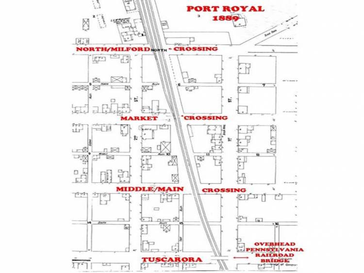
MAP OF STREET CROSSING OF PRR - This map shows the various crossings of the rail tracks at Port Royal. These crossings were used before construction of the Railroad Bridge in 1910. The Milford Street Crossing was the primary crossing since it had direct access to the covered Juniata River Bridge. The other crossings served primarily as links to First (Water) Street. (Map courtesy of Wayne Taylor)
Contributed by rkohler3 on 8/19/19 - Image Year: 1889
From the time the Pennsylvania Railroad tracks were laid through Perrysville (Port Royal) until the Railroad Bridge was opened in 1910, the primary point for crossing the tracks was at the Milford Street Crossing. Traffic going either east toward First (Water) Street and the Juniata River Bridge or west from those same locations, traversed the tracks at Milford Street. This traffic would await a signal from the crossing guard and then proceed when the clear signal was given.
The Milford Street Crossing was closed after the Railroad bridge was opened. At the time of the closing, Milford Street was the northern boundary of the town and everything north of the street was considered in Milford Township. (The Sanborn Fire Insurance Maps refer to this street as North Street rather than Milford Street.) Today the area north of the Street is part of the Borough of Port Royal.
At the time of the closing of the crossing the following appeared in the Juniata Tribune - 16 Feb 1911:
"A rule was granted on the Supervisors of Roads of Milford Twp. to show cause why Milford Street, on the north line of Port Royal Borough, should not be vacated and closed to public traffic travel where it crosses the Penna. RR, an overhead bridge having been built at Market St."
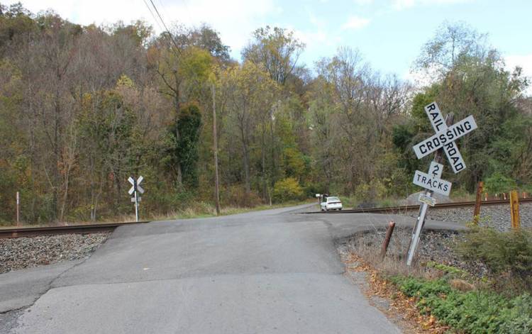
There is another crossing about one and a half miles northwest of Port Royal, near Route 333. This crossing is locally known as Casner's Crossing, and this crossing is still being used (2019).
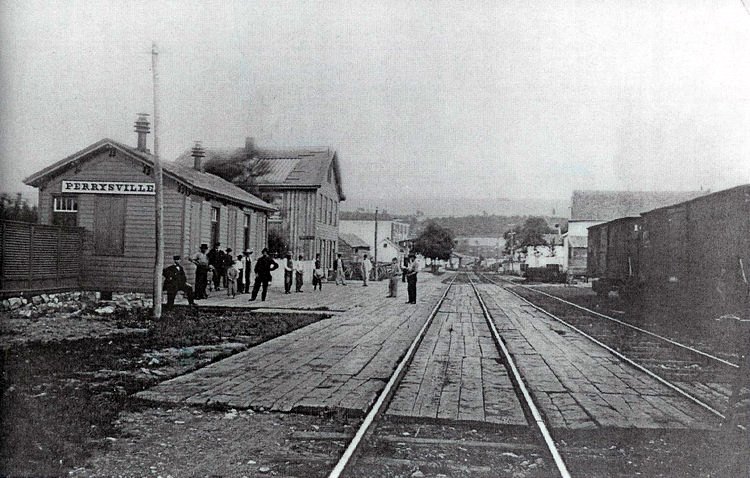
Contributed by rkohler3 on 11/30/09 - Image Year: 1875
This photo shows a view of the Milford Street crossing just past the railroad cars on the right. The original PRR Perrysville passenger station is on the left of the photo. Next to the station is a large rooming house, sometimes called the Railroad House. The railroad cars to the right are on a siding that runs along side the PRR Freight House. The PRR had not yet added the third and fourth tracks to the Middle Division of its line through the town.
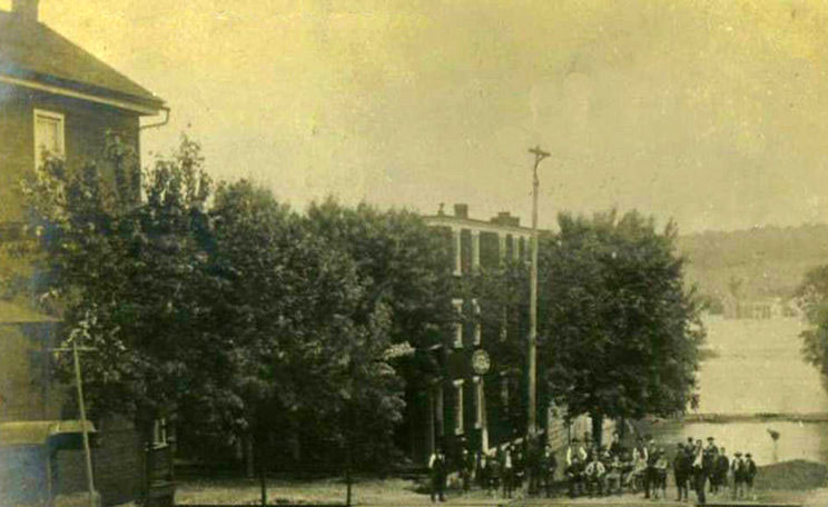
Contributed by rkohler3 on 2/13/13 - Image Year: 1889
MARKET STREET CROSSING: The Market Street Crossing in foreground. Just across the tracks is the Tuscarora House (first Hotel in the town, owned and operated by J. McManigal). The picture was taken during the flood of JUNE 1889. (Photo from "Port Royal Sesquicentennial 1812-1962 p. 13).
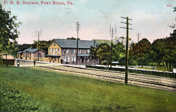
Contributed by rkohler3 on 8/18/11 - Image Year: 1904
The Milford Street Crossing can be seen in the center of this postal card. The watchmen's shed is at the far left of the picture. Someone appears to be standing in the middle of the Crossing. The large building in the photo was the Tuscarora House, the town's first hotel and the smaller building was the first PRR Station for Perrysville (Port Royal).
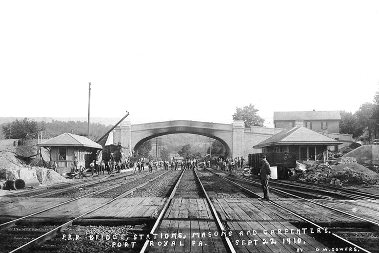
Contributed by rkohler3 on 11/30/09 - Image Year: 1910
This photo is looking southeast toward Mexico and shows the newly completed PRR Bridge in the center of the picture. The Milford Street Crossing is in the foreground of the photo with a crossing guard standing on the crossing timbers. The new Port Royal Station is nearly complete on the right and the new westbound passenger shelter stands on the left. The debris around both buildings suggests that there was additional work remaining.
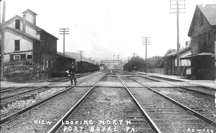
Contributed by rkohler3 on 11/30/09 - Image Year: 1910
A view looking northwest toward Mifflin with the Milford Street Crossing in the foreground. A crossing guard stands on the crossing timbers. The boarding house can be seen on the right and the original PRR Station just beyond it. On the left is the Wisehaupt Grain Elevator and the PRR Freight House.
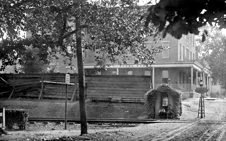
Contributed by rkohler3 on 11/30/09 - Image Year: 1910
CROSSING GUARD SHACK - This photo is looking across the Milford Street Crossing from First (Water) Street toward Second Street. The ivy covered crossing shack sits close to the intersection of Milford and Second Streets. The Hotel Royal is clearly visible in the background and the boards seem to be storage sheds for the building that is taking place with the station.
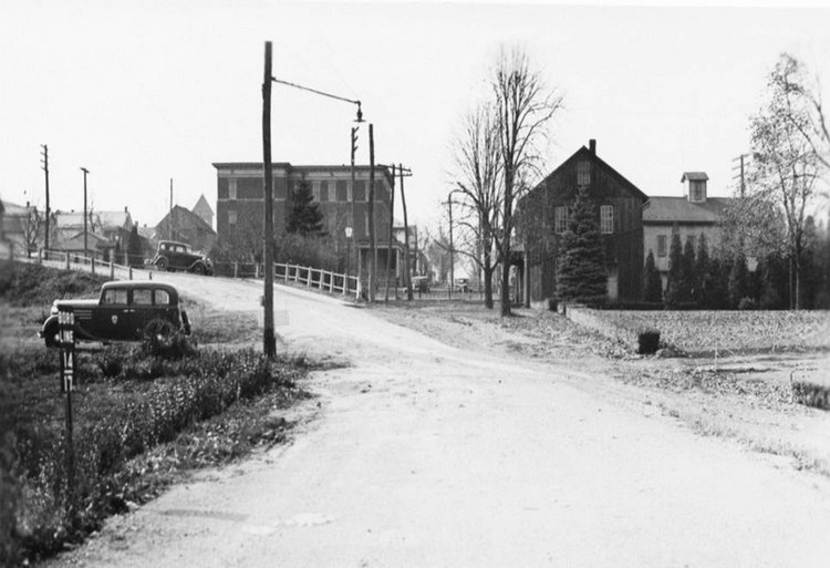
Contributed by ray on 3/2/13 - Image Year: 1939
MILFORD STREET CROSSING HAS BEEN CLOSED: The parked cars appear to be waiting to cross the tracks but the Crossing has been closed. The entrance to the covered Juniata River Bridge can be seen in the distance. The RAILROAD HOUSE is just across the tracks on the left, and behind it is one of the POMEROY HOUSES. A vehicle appears to be descending the hill from the Railroad Bridge. (Photo submitted by Wayne Taylor)
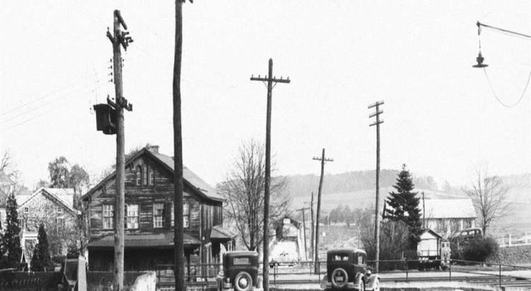
Contributed by rkohler3 on 3/2/13 - Image Year: 1939
MILFORD STREET CROSSING HAS BEEN CLOSED: This photo shows the road at the bottom of the hill onto the Juniata River Bridge and also onto First Street. The Railroad House is the darker building on the middle right and Hotel Royal is on the middle left. Milford Street is directly ahead between the two buildings. It appears that the photo was taken from in front of the Pomery Houses. (Photo submitted by Wayne Taylor)
Contributed by rkohler3 on 9/21/19 - Image Year: 1920
CLOSED MILFORD STREET CROSSING: The Railroad House is in the foreground, just across the tracks, with the Covered Juniata River Bridge in the background. The Milford Street Crossing has been closed because the Railroad Bridge was built. (Photo courtesy of Wayne Taylor)
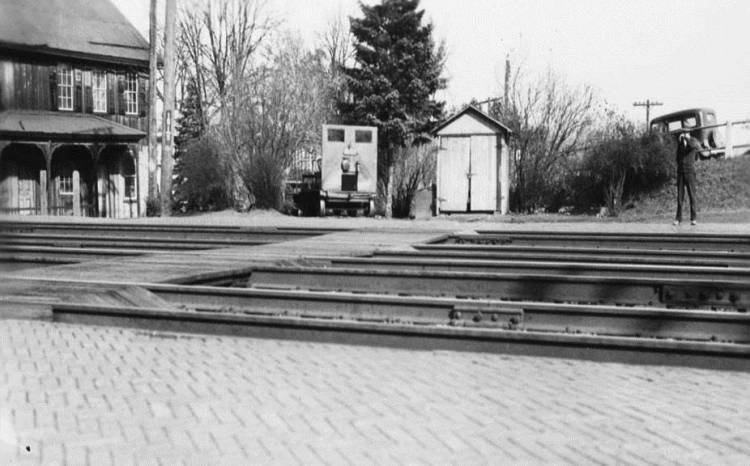
Contributed by ray on 8/25/19 - Image Year: 1925
MILFORD STREET PASSENGER CROSSING This photo shows the Milford Street Crossing after it had been closed to vehicular traffic but was still available for foot traffic. It was often used to take a mail cart across the tracks or allow westbound arriving rail passengers to cross the tracks to the new station or transfer to the TV Line. A "Dinky" car for hauling a track gang can be seen across the tracks and the RAILROAD HOUSE is at the left edge of the photo. (Photo courtesy of Wayne Taylor)
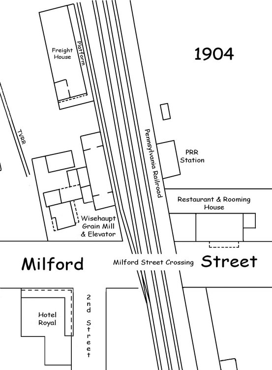
Contributed by rkohler3 on 12/2/09 - Image Year: 1904
This map shows the Milford Street Crossing of the Pennsylvania Railroad tracks in 1904. The locations of Hotel Royal, Wisehaupt Grain Elevator and Mill, the PRR Freight House and the first PRR Passenger Station can be seen in relation to the Crossing.
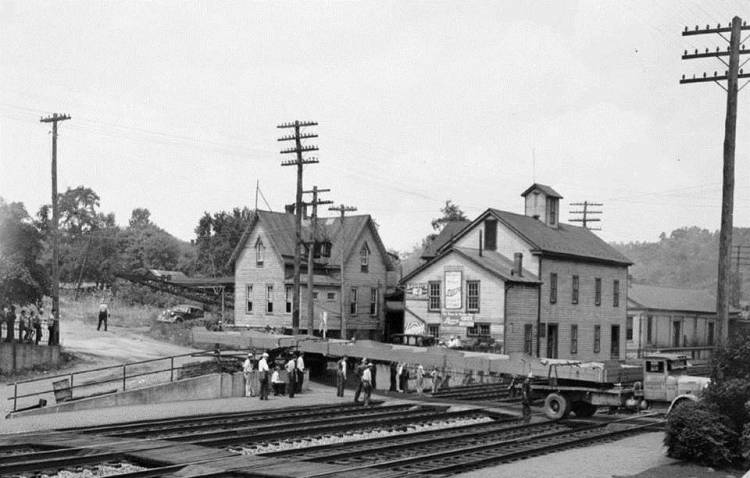
Contributed by ray on 8/26/19 - Image Year: 1937
BRIDGE GIRDER ARRIVES A girder crosses the MILFORD STREET CROSSING for construction of the new STEEL RIVER BRIDGE. (Since the Crossing had been closed in 1911 after opening of the RAILROAD BRIDGE, the Crossing must have been reopened for this special purpose.) The GOODMAN GRAIN ELEVATOR can be seen behind the girder. (Photo courtesy of Wayne Taylor)
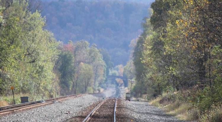
Contributed by ray on 9/2/19
VIEW FROM CASNER'S CROSSING: This photo was taken from Casner's Crossing looking southeast toward the PORT ROYAL RAILROAD BRIDGE which is about a mile and a half away. (Photo courtesy of Wayne Taylor)
Contributed by rkohler3 on 9/2/19 - Image Year: 2016
CASNER'S CROSSINGS LOOKING TOWARD ROUTE 333 (Photo courtesy of Wayne Taylor)